Coloured Population map: Grahamstown 2011

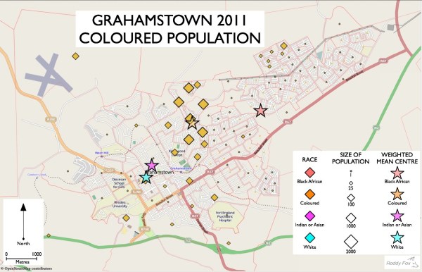
The distribution of the coloured population (total 7615) is the second map in this series showing Grahamstown's racial distributions in 2011.  The main concentration is still immediately to the west of the townships, especially to the northern side of the urban area.  This isn't surprising as the coloured group area was located there: north of... Continue Reading →

Black African Population map: Grahamstown 2011

This is the first of a number of posts mapping racial data and shows Grahamstown's Black African population using information extracted from the 2011 Census. The most detailed geographical statistics from the Population Census consist of information for very small areas (the so called small area layer).  There are over 50,000 small areas in South... Continue Reading →

MyCOE/SERVIR East Africa: outreach seminar (Linköping University)

Last December's MyCOE/SERVIR fellowship workshop in Nairobi has already been the inspiration for new research work at Rhodes University that integrates geographical technologies with field-based research. Kate and I are presenting a seminar at Linköping University's TEMA-Vatten today (and at Northampton University next week) that looks at extreme weather events in the Sneeuberg Mountains of... Continue Reading →

MyCOE/SERVIR programme: ground truthing in the Drakensberg, South Africa

It is three months since Natalie and I returned from the MyCOE/SERVIR programme in Nairobi.  Since then Natalie has started the new academic year - her Honours year - and I have started six months sabbatical leave.  But we have been busy with the research programme: acquiring and analysing Landsat, SPOT and Ikonos data for... Continue Reading →

MyCOE/SERVIR: at the Regional Centre and on the Field Trip

It has been one week of intensive work since the cocktails posting .... so here are my pictures and some quick reflections.  Lots of lab work has been done at the Regional Centre for Mapping of Resources for Development: remote sensing applications, GIS work, mentor presentations.  The day has started with the walk from ICIPE... Continue Reading →

Population Census 2011: Distribution of Population Groups in the Eastern Cape

My earlier post concerning the recently released 2011 Population Census looked at the age-sex pyramids for Makana Municipality.  This week more data was made available on the Statssa website which has enabled me to take a first look at the distribution of population groups in the Eastern Cape Province.  Once again the data is recorded... Continue Reading →

Create a website or blog at WordPress.com

Up ↑