GIS Mapping shows High Court Should Remain in Makana

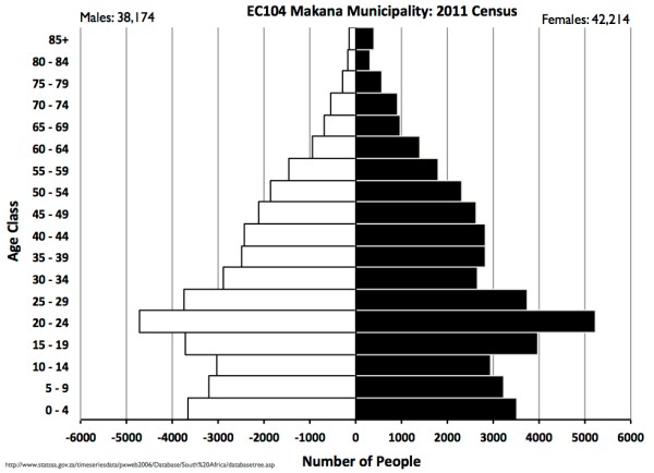
Every few years the Government does its best to wreck the legal and economic life of Makana by proposing to move the High Court to Bhisho. In the mid 1990s I assisted the fight to keep the court here with some maps and population data that showed Makhanda (what was then Grahamstown) to be the... Continue Reading →

Aloes and Stars, new Amakhala Image in the Room of Dreams @NAF2022

I'm enjoying the flexibility of a virtual exhibition space at #naf2022. It's meant that I can easily add this new image of Amakhala - taken a couple of weeks ago- to the Room of Dreams. Aloes, Winter Stars and Dawn Light, Amakhala It fits very nicely in the centre of the wall of landscapes with... Continue Reading →

Egazini in ruins

Yesterday was the bicentenary of the Battle of Grahamstown.  I've always intended to visit the site but somehow never managed it. So this afternoon I took a brief gap in the rain to go across the valley to Egazini: the township based heritage site. On the way there you get a good view of the... Continue Reading →

Population Census 2011: Makana Municipality’s Age-Sex data

There has been a good deal of public discussion about the recently released 2011 population census and it is now possible to start to see some of the local level information. I downloaded the spreadsheet of age-sex information for all of the country's municipalities from the website of Statistics South Africa.  Then it was a... Continue Reading →

Create a website or blog at WordPress.com

Up ↑